|
||||||||||
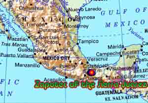
| The Zapotec of the Sierra Juarez refer to themselves as Bene Xon. The Zapotec are the third largest indigenous group in Mexico after the Nahua and the Maya. They are located in three geographic areas primarily in the State of Oaxaca. The three regions are the central valleys, the Sierra Juarez and the Isthmus of Tehuantepec. The Zapotec language has a large number of unintelligible dialects, which give each region a distinctive character, and differentiates them from one another. The cultural, language, traditions, agricultural rites are basic to being Zapotec. The Sierra Juarez is extremely mountainous with deep valleys and large ranges of mountains. The Sierra also known as the Sierra Norte of Oaxaca extends from the volcano Pico de Orizaba in Vera Cruz westward to the coastal mountains of the Pacific Ocean. The districts are Ixtlan de Juareez, Valla Alta, Yautepec, Choapan and Mixe Tuxtpec, Cuicatlan, Mazatlan. The area described here covers 17,286 square kilometer or 6674.16 Square miles. The highest peaks in are Zempoaltepetl 3700 msnm (12139.1 feet), Cerro de Cuajimolollas 2814 msnm (9232.28 feet), Cerro Campanario 2600msnm 8530.18 Feet there are valleys which are only 500 msnm (1640.42 feet). The main Zapotec districts are Villa Alta and Ixtlan de Juarez with a small presence in the district of Choapan. to continue Click here |
|
|||||||||
|
||||||||||